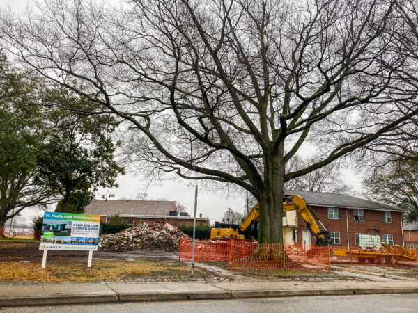
In early January 2021, amidst the COVID-19 pandemic and the unprecedented economic upheaval that it brought with it, bulldozers began knocking down the walls of Tidewater Gardens, a 618-unit public housing complex in Norfolk, Virginia (fig. 1). Norfolk is a low-lying coastal city of about 235,000 residents in southeastern Virginia. The demolition of Tidewater Gardens is only the first step in a broader plan pursued by the city of Norfolk and the Norfolk Redevelopment and Housing Authority (NRHA). Their ultimate goal is to demolish Tidewater Gardens and two other adjacent public housing complexes,1 an area that altogether make up what is known as St. Paul’s Quadrant, a 250-acre parcel of land populated by approximately 4,200 people living in 1,674 units of public housing immediately east of downtown Norfolk.2
According to the city and the housing authority, the plan is to temporarily relocate public housing residents into market-rate rentals throughout the metro area using Housing Choice Vouchers (HCVs, previously known as Section 8 vouchers), conduct significant stormwater and drainage improvements to the land, and construct a multi-use, mixed-income development in its place, to which “temporarily” displaced public housing residents will first have “right of return.”3 From the city’s perspective, this is all about choice. Residents can choose to use housing vouchers to permanently move anywhere they want, or they can choose to return to the redeveloped area upon its completion.4 The whole redevelopment plan is partially funded by a Choice Neighborhoods Initiative grant (emphasis added) from the U.S. Department of Housing and Urban Development.5
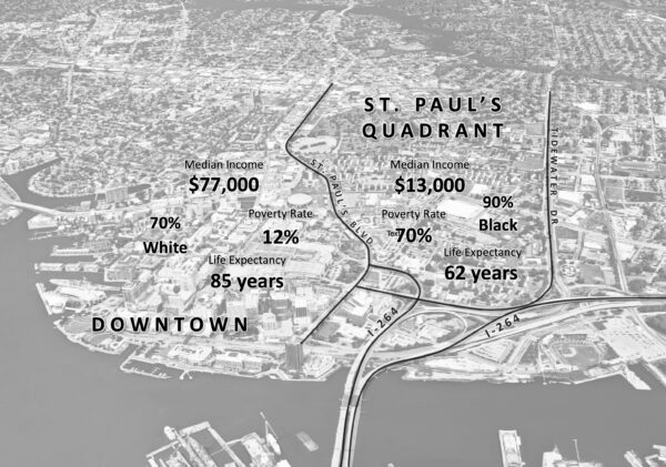
But even a $30-million HUD grant and a battery of glossy architectural mock-ups haven’t succeeded in convincing many that this won’t go the same way as so many redevelopment schemes in Norfolk’s long history of urban renewal: removal (of population), demolition (of housing), redevelopment (of land), and ultimately the permanent displacement of the areas’ indigenous populations. And why should it? St. Paul’s Quadrant comprises the highest poverty, social vulnerability, and proportion of African American census tracts in Norfolk. Immediately to the west, just across St. Paul’s Boulevard, are some of the city’s whitest, highest-income, and highest-rent residential and commercial neighborhoods (fig. 2). On the street, local historians have begun digging into a long history of displacement-in-the-name-of-redevelopment in Norfolk. Terms like “gentrification” and “re-segregation” are suddenly part of the city’s popular lexicon, and the redevelopment plan has been the subject of multiple exposés in local media,6 an episode of a television documentary series hosted by journalist Soledad O’Brien, and a Federal Fair Housing lawsuit.7
My aim in this article is to use a critical landscape approach to show (a) how anti-Black racism embedded in urban renewal policies in the mid-twentieth century produced the landscapes of racial inequality that we inhabit today and (b) how these landscapes constitute, in the present day, a physical stage upon which neoliberal ideologies of freedom and choice shift the responsibility of segregation and poverty to impoverished people of color, who now supposedly have the “freedom” to “choose” to live wherever they want, unincumbered by discriminatory laws, policies, regulations, or individuals.
A critical landscape approach
I began this article from the end, from the forced removal of hundreds of public housing residents from some of Norfolk’s highest poverty, most socially vulnerable, and highest proportion African American census tracts in the city. But how’d we get here? How were these urban landscapes of racial segregation and economic inequality produced? How do they continue to perpetuate and reproduce racialized economic, environmental, and health inequalities? And how can we shift our conceptualization of this inequality not as a natural, if unfortunate, outcome of some apolitical history but as structural violence—social murder, according to Engels8—facilitated by the naturalizing force of the landscape which itself constitutes a form of symbolic violence that occludes the historical production of racial segregation in the first place and shifts the blame for contemporary inequality onto the bodies of the marginalized themselves?
A critical landscape approach is useful in answering precisely these questions. The basic premise of a critical landscape approach is that landscapes are not simply innocent, objective, or cultural representations in the land or, in the words of geographer Pierce Lewis, our “unwitting autobiography.”9 Rather, the landscape is the physical manifestation of social processes and struggles as they play out and are materialized and solidified in place.10 The physical, material, urban landscapes that surround us and that we inhabit are not natural, accidental, or coincidental; they are actively produced by individuals and groups with the social, political, and economic power to shape and produce them to their own interest. Accordingly, “[a]s a concretization of social relations, and as a foundation for the further development of those social relations, landscape literally marks out the spatial extent and limits of social justice. The spatial form of the landscape is both the result of and evidence for, the kind of society we live in” (NA, 45). That is, our urban landscape—the way we physically construct our cities and order ourselves within them—reflects the kind of society we have created for ourselves.
But the landscape doesn’t just reflect the kind of society we have created for ourselves. The landscape also has power; it does work.11 If the landscape is not accidental or natural but is actively produced by unequal and intersecting arrays of power within and across societies, the power of the landscape is to occlude precisely those social forces that produced it in the first place. Not unlike Marx’s commodity fetishism, when we look at our material urban landscapes, we only see the finished product: the highway, the high-rise apartment building, the coal-fired power plant, the suburban development, the garbage incinerator. The physicality of interstate highways themselves belie the systematic removal of Black and Brown neighborhoods in urban areas across United States to make way for them;12 the physicality of suburban developments occlude the overtly racist public policies that were in place for much of the twentieth century that kept these suburbs almost entirely white;13 the materiality of a coal-fired power plant—and the fact of its placement in one particular place rather than any other—says nothing about the struggles of marginalized communities to resist plant sitings in their neighborhoods all across the country.14 And because the materiality—the brute physicality—of the landscape says nothing about the conditions of its production, the power of the landscape is thus to render natural the social forces of its production.15 Profoundly unequal social processes are materialized, made real, and made to seem natural in the landscape.
In a certain sense, the landscape has the power of ideology. As Donald Mitchell writes, “It has the power to naturalize and make seem inevitable what is really constructed and struggled over” (NA, 44). But, Mitchell continues, there is a key difference between ideology and landscape: “unlike ideology, which is as transient as words, landscape is solid, physical, the opposite of ephemeral. Landscape is thus ideology made solid: a produced space that does more than represent. It guides.”16
In an urban American context, the landscape becomes the physical stage upon which our bootstraps ideology of individual neoliberalism plays out. The physicality of the landscape, the fact of its existence, serves to reinforce “the belief that systematic discrimination is a thing of the past … [since] we as individuals can simply choose to live wherever we want, and thus that we are individually responsible for both the benefits and consequences of those choices.”17
Urban renewal in the United States
The roots of urban renewal lie in FDR’s New Deal legislation. In 1934, the Roosevelt Administration created the Federal Housing Administration (FHA) to help the home-building and finance industries during the Great Depression. Three years later, noting the squalid housing conditions in the United States, Roosevelt declared in his State of the Union address that “millions of Americans still live in habitations which not only fail to provide the physical benefits of modern civilization but breed disease and impair the health of future generations.”18 Just weeks later he returned to the topic of housing in his second inaugural address, saying that he sees “one-third of a nation ill-housed, ill-clad, ill-nourished.”19
Less than a year after that, on September 1, 1937, Roosevelt signed into law the Housing Act of 1937, also known as the Wagner-Steagall Housing Act. This law was designed to achieve two objectives in the context of the Depressions. First, it would provide low-cost housing for the “deserving” poor—a population understood to be poor due to no fault of their own and nearly universally understood to be white20—and second, it would create construction jobs and therefore help to spark economic growth.21 The law allocated $500 million for the construction of low-cost public housing which would be built and owned by local housing authorities, giving localities the ability to choose whether or not to participate. In a concession to conservative lawmakers who worried that new public housing would compete with private rental markets and “foster dependency among the poor,”22 ongoing operations of public housing would be rent-funded, and public housing tenants’ income could not exceed five times the rent.23 In what would lay the groundwork for decades of slum clearance, the law also required the demolition of one unit of slum or blighted housing for every new unit constructed.24 By the end of the 1940s, approximately 200,000 units of public housing had been built or contracted.25
In response to the persistent housing shortage following WWII and after a long battle between progressive and conservative forces in Congress, the Taft-Ellender-Wagner Housing Act of 1949 was signed into law. This new law approved the construction of over 800,000 more units of public housing, though it maintained income restrictions and the requirement that one unit of slum housing be demolished per unit of public housing constructed. The law also provided new funds for local housing authorities to acquire blighted land through eminent domain and condemnation proceedings and—in a shift from the 1937 law—allowed for the private development of cleared land.26 The Housing Act of 1954 amended the 1949 law, placing a new emphasis on “urban renewal” and loosening requirements on residential redevelopment, thereby empowering cities and municipalities to resell cleared land to private commercial and industrial interests.27
From the late 1930s to the early 1970s, vast swaths of urban space, largely populated by low-income, non-white communities, were bulldozed and repurposed for new land uses. And while housing was the ostensible goal of all three housing laws, as the number of federally funded urban renewal projects increased throughout the 1950s and 1960s, the number of new public housing units built annually was cut in half between 1953 and 1962.28 It ultimately took over two decades to construct the 810,000 public housing units that were approved in the 1949 law—far more than the intended six years.29 In the end, housing was built on less than a fifth of all land cleared.30
Urban renewal ended with the passage of the 1974 Housing and Community Development Act, which shifted low-income housing policy away from public housing and toward individual housing support via Housing Choice Vouchers. The HCDA and the subsequent 1998 Quality Housing and Work Responsibility Act entrenched a discourse of individual choice into housing policy, which I return to below.
The centrality of race
Race and racism were at the heart of slum clearance and urban renewal. Because federal urban renewal policies were enacted through local housing authorities, it was common for explicit racial animus to permeate local planning decisions. For instance, hundreds of cities contracted St. Louis-based urban planner Harland Bartholomew to develop master plans for urban renewal. An avowed segregationist, Bartholomew “was well versed in the laws surrounding urban planning; he knew how planning was legally justified, how planning could and could not be used to segregate, and for what purposes government could use planning to acquire land.”31 One intent of his master plan for St. Louis was to prevent the movement into “finer residential districts … by colored people” and to “contain” the spread of neighborhoods “where values have depreciated, [and] homes are either vacant or occupied by colored people” or boarding houses.32 In Richmond, VA, Bartholomew’s master plan “coincided with the prevailing local attitudes toward the proper social division in cities.”33
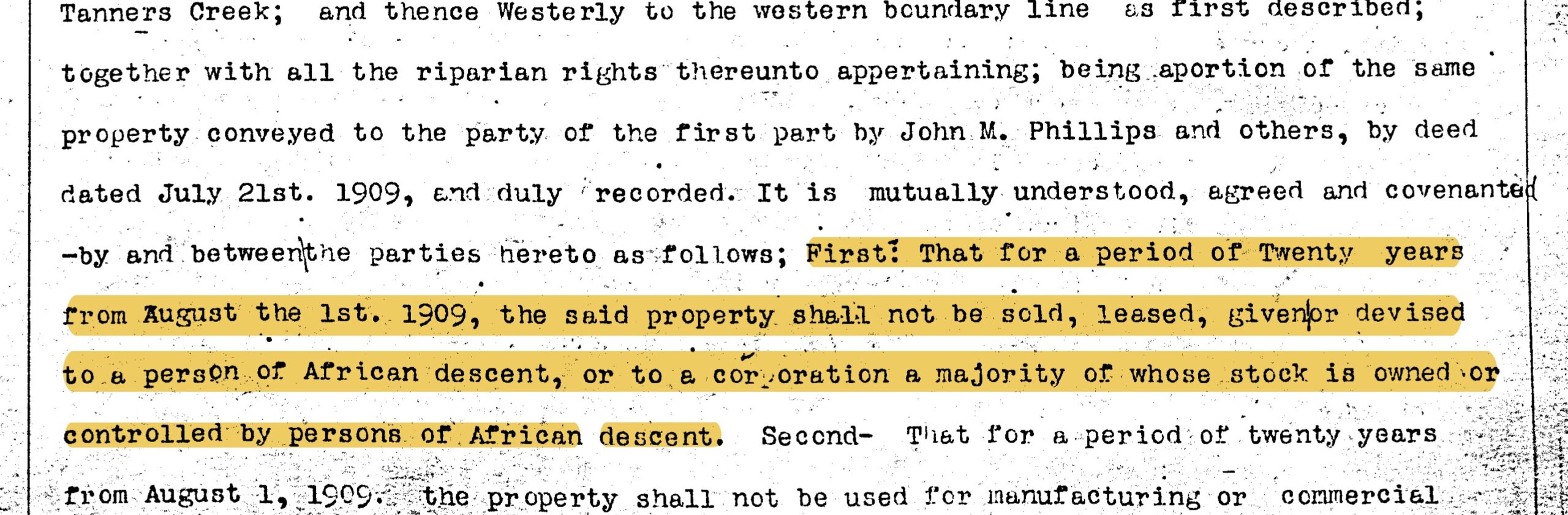
Vitally, the blighted conditions that came to make Black neighborhoods targets for slum clearance and urban renewal were produced through a constellation of segregationist and disinvestment policies and practices enacted at local, state, and federal levels unfolding over many decades. Following Plessy v. Ferguson (1896),34 cities began passing segregation ordinances for public transportation, schools, commerce, and housing (URV). In 1912, for instance, the Virginia General Assembly passed legislation permitting cities to adopt racial segregation ordinances. And although the U.S. Supreme Court ruled in 1917 that residential segregation ordinances were unconstitutional,35 soon thereafter it affirmed in Corrigan v. Buckley (1926) that racially restrictive covenants were enforceable (fig. 3).36 During the Depression, the FHA created a mortgage insurance system that enabled banks to issue mortgages with lower interest rates and longer terms in order to reduce monthly mortgage payments and help homeowners avoid foreclosure.37 However, the FHA specifically targeted this insurance program in upper-income neighborhoods, effectively excluding the low-income urban neighborhoods where most Black homeowners lived (NE). Furthermore, the FHA prioritized financing new construction, “which at this point in American history had rarely ever been built for occupancy by Black homeowners” (NE, 4).
Apart from the FHA’s insurance program, the Home Owners’ Loan Act of 1933 created the Home Owners’ Loan Corporation (HOLC) to address surging mortgage defaults. The HOLC was mandated to “refinance loans from borrowers who were ‘in hard straits largely through no fault of their own’” by purchasing “distressed residential mortgages from private lenders and then refinanc[ing] them with the original borrowers at easier terms” (NE, 5, 28). Between 1933 and 1936 the HOLC refinanced roughly 20 percent of all existing mortgages under lower interest rates, amassing a portfolio of nearly one million loans (NE). And while the HOLC refinanced loans for Black homeowners roughly in proportion to their population at the time, they did so within existing patterns of residential racial segregation (NE).
The HOLC’s legacy is perhaps one of the most misunderstood dimensions of New Deal housing policy. In order to manage the risks associated with this portfolio, the HOLC created a now infamous series of maps assessing risk and home values in over 200 different cities.38 These maps used four colors—green, blue, yellow, and red—to rate neighborhoods from best to riskiest. And while these maps have come to be understood in the popular culture as guiding discriminatory lending practices,39 new research shows that these maps and accompanying data sheets actually reflected already-existing lines of racial segregation and disinvestment in minority neighborhoods.40
By the time the housing laws of 1949 and 1954 were signed into law, multiple local, state, and federal policies, alongside and often in coordination with the actions of urban planners, banks, and realtors spanning more than half a century, had created the blighted conditions that were then used as the justification for slum clearance and urban renewal (URV). Because of both explicit and implicit racial discrimination embedded in this history, the terms “slums” and “blight” became “widely understood euphemisms for African American neighborhoods,”41 and “urban renewal,” in the words of James Baldwin, became a euphemism for “Negro removal.”42
And, as I will show below, these landscapes of urban renewal have become powerful tools in the ongoing reproduction of contemporary American ideologies surrounding race and housing choice.
Landscapes of inequality in Norfolk, VA
The forces of urban renewal would dramatically reshape the urban and racial geography of Norfolk, Virginia. As in other cities across the state and country, Norfolk’s racial geography in the 1930s already exhibited the hallmarks of significant public and private investment in white neighborhoods and disinvestment in Black ones. Take, for instance, the written descriptions from the 1940 HOLC “redlining” map of two Norfolk neighborhoods, one white and one Black, just miles apart from each other. The all-white Lockhaven neighborhood was described as “the best residential section in Norfolk” that was “park like (sic) in general appearance” (fig. 4). The description continues:
Many of the streets are winding and attractive …. The central portion of the area, known as Glencove, is the principal scene of present construction activity. A special assessment has been agreed upon for this area in consideration of street improvements, which will expire in 1946. All construction is sound and the population is stable, with excellent pride of home ownership evident in the maintenance of lawns and shrubbory (sic) …. The area is cool in summer because of prevailing winds from the southwest. The Norfolk Country Club and tennis courts are located within the area, and the golf course is approximately 1 mile northeast. Schools, churches, neighborhood stores convenient.43
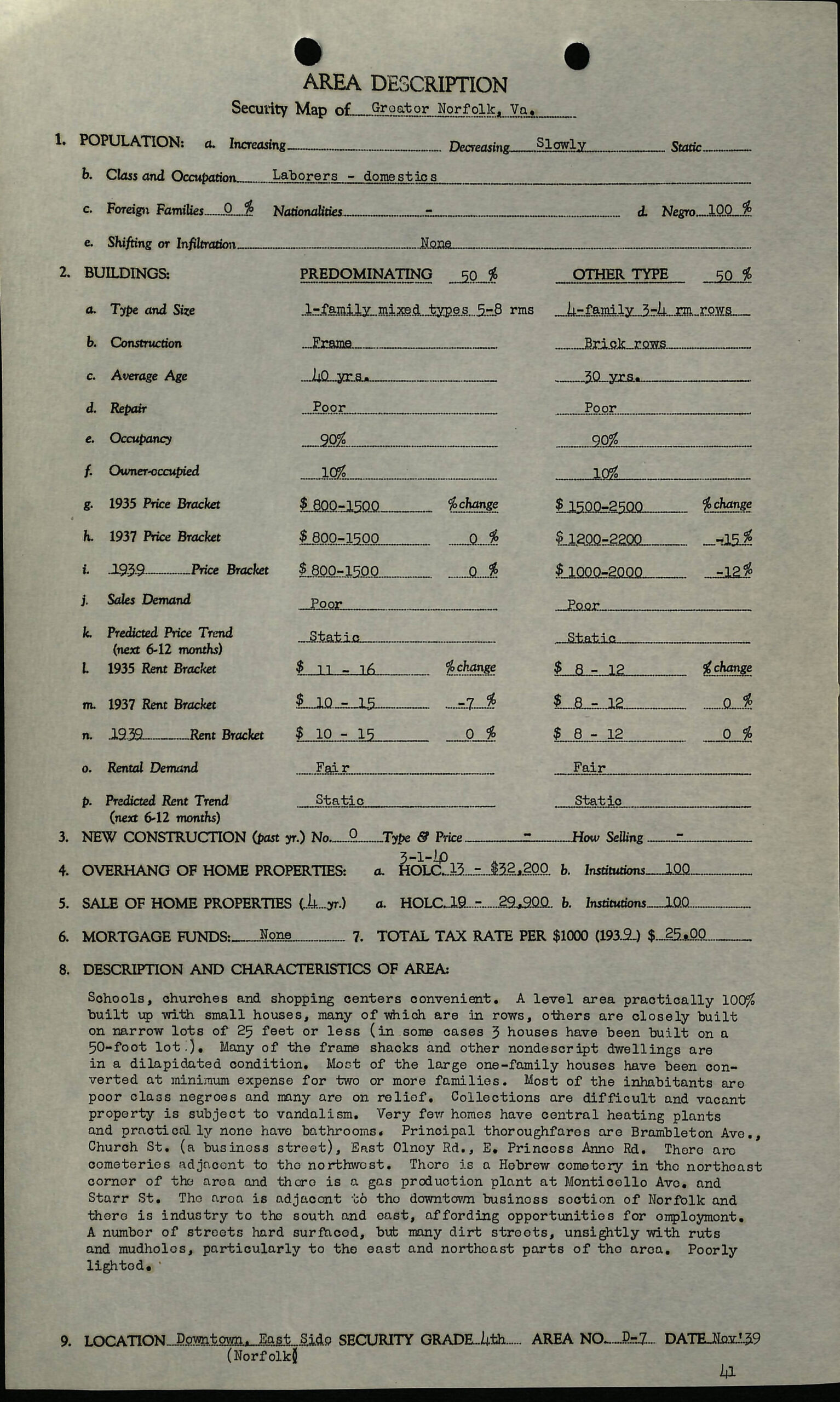
Less than five miles south, a segregated and redlined neighborhood east of downtown that would later come to be called St. Paul’s Quadrant exhibited the blighted housing conditions that would soon be characterized as slums, thus justifying their removal (fig. 5):
A level area practically 100% built up with small houses, many of which are in rows, others are closely built on narrow lots of 25 feet or less (in some cases 3 houses have been built on a 50-foot lot). Many of the frame shacks and other nondescript dwellings are in a dilapidated condition. Most of the large one-family houses have been converted at minimum expense for two or more families. Most of the inhabitants are poor class negroes and many are on relief …. Very few homes have central heating plants and practically none have bathrooms …. There is a Hebrew cemetery in the northeast corner of the area and there is a gas production plant at Monticello Ave. and Starr St. The area is adjacent to the downtown business section of Norfolk and there is industry to the south and east …. A number of streets hard surfaced, but many dirt streets, unsightly with ruts and mudholes, particularly to the east and northeast parts of the area. Poorly lighted.44
In 1936, the Works Progress Administration (WPA) surveyed 2,000 housing units in several of Norfolk’s Black neighborhoods, concluding that more than 75 percent lacked flush toilets and baths, and more than 200 were totally unfit for human habitation.45 In 1940, Nathan Straus, then head of the FHA, toured this and other blighted areas of the city, noting that this was, “without a doubt the worst slum he had seen anywhere in the United States.” He told city leaders that Norfolk would be “first on the list” for redevelopment funds.46
In 1938 the Virginia General Assembly passed legislation allowing cities and municipalities to create local housing authorities, and in 1940 Norfolk City Council voted to create the Norfolk Housing Authority as the city’s primary vehicle to marshal federal housing funds (BWB; URN). By the end of WWII the term “redevelopment” was added to its title, and slum clearance and urban renewal became central to the mission of the NRHA. A 1949 master plan for urban renewal in Norfolk described extensive blight and concluded that “large scale redevelopment is the only chance the city ever has had to accomplish a drastic modernization of its heart” (BWB, 13).
What followed was a classic self-fulfilling prophecy within urban renewal. Through both formal statements and informal telegraphing, city leaders would single out specific neighborhoods as blighted and in need of redevelopment. In many specific cases, these neighborhoods were vibrant, if run-down communities. The depiction of these areas as blighted by city leaders, however, disincentivized the city from extending or continuing to provide services to areas that may soon be redeveloped and landlords and homeowners from continuing to invest in their properties, concerned that the city would ultimately bulldoze their investments. As I show below, public and private disinvestment came as a result of telegraphing slum clearance and, in many cases, exacerbated or even created the very slum conditions that would ultimately justify their removal (BWB).
An analysis of urban renewal in Norfolk cannot be separated from the racist and sometimes violent backlash to the Supreme Court’s landmark decision in Brown v. Board of Education (1954) happening across Virginia at the same time.47 Known as Massive Resistance, local and state political leaders across Virginia adopted a set of strategies to resist public school integration. One strategy was simply to close public schools rather than integrate them.48 Schools in Norfolk, for instance, closed for five months in 1958, while Prince Edward County public schools closed for five full years, only reopening after the Supreme Court deemed these closures to be unconstitutional.49 Another strategy was the creation of “segregation academies,”50 publicly-funded segregated white private schools that wouldn’t be forced to integrate until 1976 when the U.S. Supreme Court found them to be contrary to federal law.51 Nearly two dozen segregation academies opened in Virginia.
Beyond school closures and segregation academies, city leaders in Norfolk also reasoned that if they could maintain residential racial segregation in neighborhoods, they could maintain de facto segregated public schools, even in the face of Brown (BWB). Slum clearance and urban renewal became the primary vehicle to achieve this end. Between 1951 and the formal end of urban renewal in 1973, every single racially integrated neighborhood in Norfolk was targeted for slum clearance. Populations were displaced, neighborhoods were bulldozed, and racial segregation was not only maintained but deepened (URN).
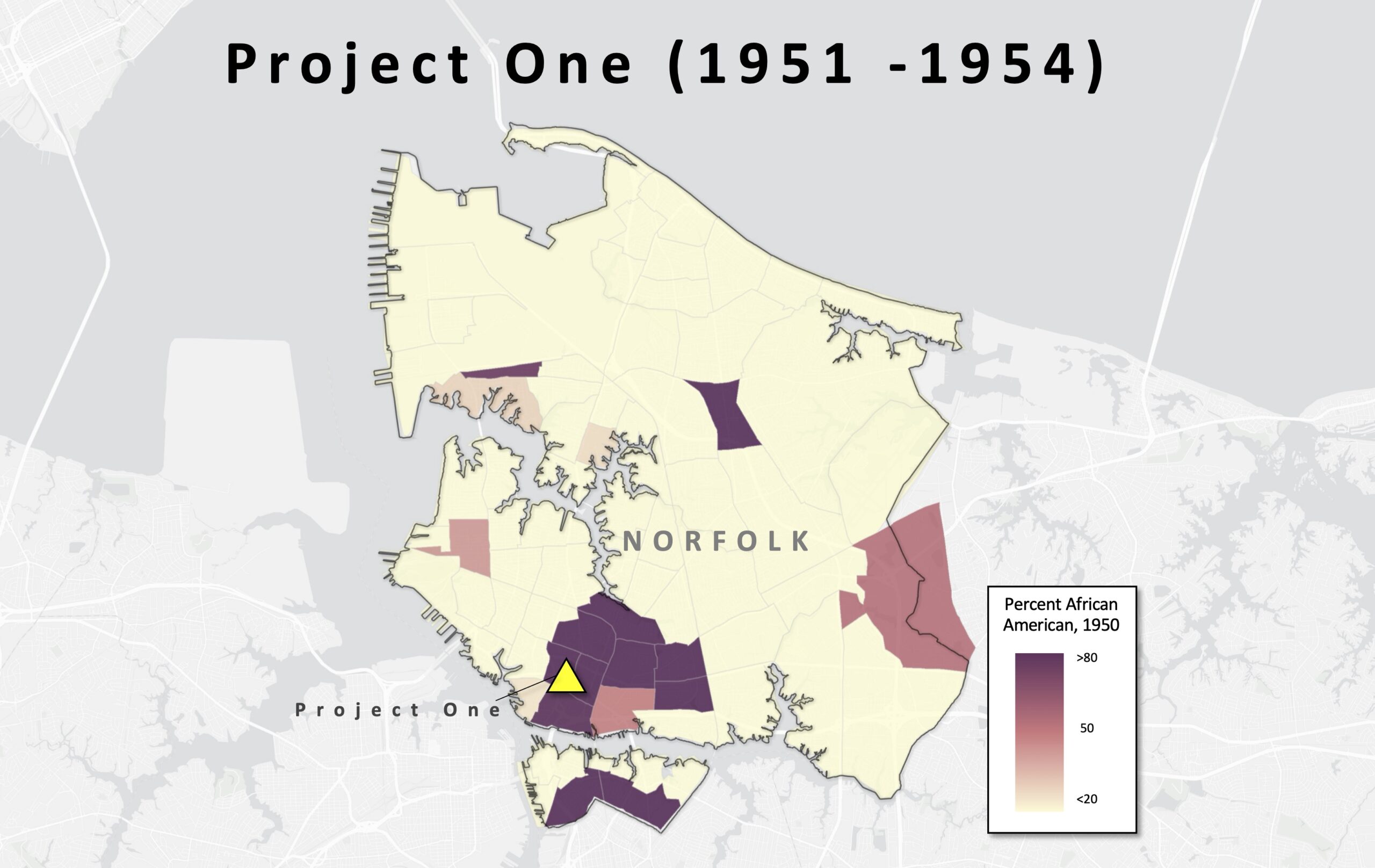
Project One
In 1951, the city broke ground on Project One (fig. 6), the first urban renewal project in the United States. This project was focused in the area described above that is today known as St. Paul’s Quadrant. At the time, the census tracts that made up the area were over 95 percent African American. After decades of neglect and disinvestment, the area represented some of the most squalid, blighted neighborhoods in the country (BWB). Project One would ultimately bulldoze and redevelop a 250-acre swath of land immediately adjacent to downtown Norfolk. And while Project One did result in a net increase in housing for African American families, this housing was concentrated in segregated low-rise public housing developments named Young Terrace, Calvert Square, and Tidewater Gardens. A new school—Tidewater Park Elementary—was built among the public housing developments and was specifically designed to relieve pressure to integrate nearby public schools (BWB). More than one-third of the land cleared for Project One was transformed into highways and industrial zones, physical barriers isolating the new public housing projects and reinforcing the lines of racial segregation. This was the first and only urban renewal project in Norfolk that would result in the construction of housing for the population that it displaced.
Project Two
Following the completion of Project One, the city launched Project Two, which would ultimately result in the demolition of the city’s last integrated neighborhoods, Broad Creek Village, Atlantic City, Lamberts Point, and East Main St. (fig. 7).
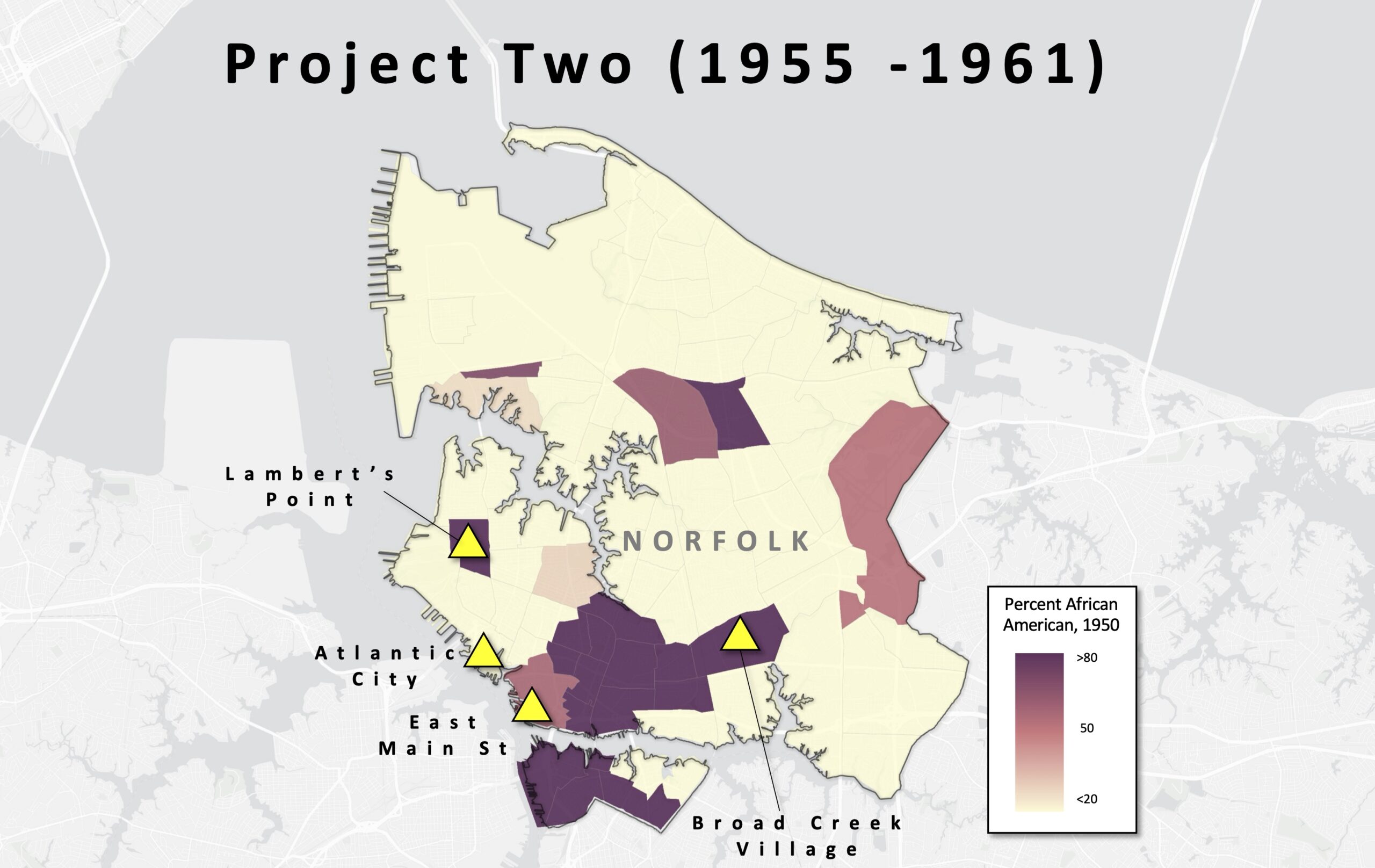
Broad Creek Village was a segregated white wartime housing project that was cheaply constructed in the early 1940s for military workers and their families. After WWII and following the desegregation of the U.S. military, the area quickly became racially integrated. In 1955, the city began discussing slum clearance in Broad Creek Village. As happened in so many other areas, reference to slum clearance itself meant that landlords stopped investing in their properties (BWB). The NRHA took control of Broad Creek Village later that year, and in 1958, it was rezoned as industrial and bulldozed specifically to prevent the development of African American housing in the area. The city did allow Black leaders to develop a 16-acre parcel known as Broad Creek Shores, but only after “the City’s chief concern, that (white) Ingleside Elementary School remain widely separated from [B]lack housing, was met” (BWB).
Atlantic City was a small, working-class neighborhood of approximately 1,000 households located southwest of downtown Norfolk. In the early 1950s, many Black families displaced by Project One were able to find rental units owned by absentee landlords in the area. By the mid 1950s, Atlantic City had become one of the only predominantly white neighborhoods where the African American population was greater than ten percent, and Atlantic City would also be the only majority white neighborhood targeted for urban renewal. According to White:
At a time when the severe housing crisis in the community had precipitated subdividing many older homes into multi-unit apartments, almost a quarter of the Atlantic City homes were till single-family, freestanding houses; another fourth were duplexes …; and close to 20 percent of the homes were less than thirty years old. In addition, more than 70 percent of the units had adequate plumbing …. More than half the units had central heating …. Undoubtedly, a number of structures had deteriorated beyond rehabilitation … but many of the deficiencies … were not only in keeping with exiting city codes, but they were also common practices during the local wartime and postwar housing crises. (BWB, 82)
The city’s health department had even run a concentrated housing code enforcement and nearly every dwelling had been brought up to code. Even so, city leaders began discussing Atlantic City’s redevelopment, causing homeowners and landlords alike to abandon property upkeep. Ultimately 1,000 homes were demolished to make way for the construction of Norfolk General Hospital and an expansion of surrounding highways and tunnels (URN). This redevelopment did not include any new housing.
Lambert’s Point was another of Norfolk’s few racially integrated neighborhoods. Census data shows that in 1940, this area was approximately thirty percent African American. Beginning in the early 1950s, Old Dominion University overtook nearly forty square blocks of the historically African American portion of Lambert’s Point. This redevelopment did not include any new housing, and today the primarily African American residential section of Lambert’s Point has been reduced to the most environmentally marginalized blocks immediately adjacent to the Norfolk Southern railyard and coal terminal. The final Project Two neighborhood was East Main Street, a majority Black section of downtown Norfolk containing some of the city’s worst slums. The redevelopment of this section of downtown resulted in the demolition of approximately 400 commercial buildings and 500 residences. No new housing was constructed. Today, East Main Street bisects the Waterside district, an area that includes the Hilton, Marriott, and Sheraton hotels, and numerous high-end restaurants and commercial buildings (URN).
Project Two “wipe[d] out all of the city’s … neighborhoods where indistinct color lines had failed to produce two distinct neighborhood school communities, one black and the other white” (BWB, 101). In the end, nearly 800 acres of land were cleared, no new housing was constructed, and an estimated 20,000 people—ten percent of the city’s population—were displaced.
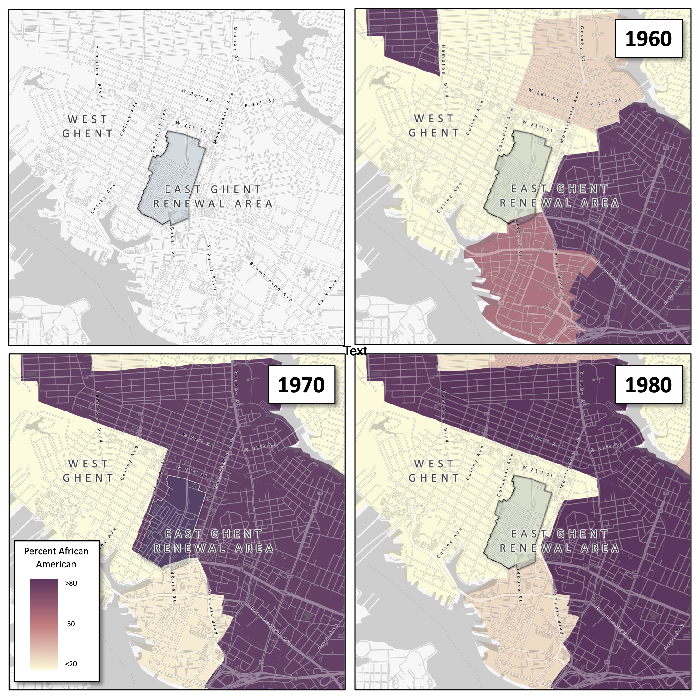
East Ghent Renewal Project
The last urban renewal project in Norfolk was the redevelopment of East Ghent (fig. 8). Situated just north of downtown Norfolk, East and West Ghent were originally developed in the 1890s as upscale, segregated, white planned communities.52 Temporary war housing was built in sections of East Ghent during WWII, which deteriorated rapidly in the years following the war. As white families abandoned East Ghent for the newly developing post-war suburbs outside of downtown, African American families, displaced from other parts of the city as a result of Project Two, began relocating into East Ghent.53 An analysis of census data shows that the population shift was so pronounced that the racial makeup of the neighborhood flipped from ninety-eight percent white to ninety percent Black in the twenty years between 1950 and 1970. In the late 1960s, city leaders declared East Ghent as blighted, and in 1969, the federal government approved the East Ghent Renewal Project. Soon thereafter, the NRHA began notifying Black residents that their properties would be acquired through eminent domain. In the end, nearly ninety acres were razed. Unlike Project Two, this urban renewal project did result in the construction of new housing, with city officials promising displaced families that they could return to the newly developed affordable housing that would be built in its place (URN). Ultimately, however, the city opted to expand its tax base by building upper middle-class homes and townhomes.54 By 1980, census data shows that the population of East Ghent was less than ten percent African American.
The End of Urban Renewal
If the 1972 demolition of Pruitt-Igoe is widely understood as symbolic of the failure of public housing policy in this era, the Housing and Community Development Act of 1974 formally ended the period of urban renewal in the United States. One of the HCDA’s most notable provisions was the creation of the Section 8 Housing Program, which represented a major shift away from public housing and toward an emphasis on flexibility and choice for low-income households in the private rental market. A generation later, the Quality Housing and Work Responsibility Act of 1998 rebranded Section 8 vouchers as “Housing Choice Vouchers,” further entrenching the neoliberal buzzwords of flexibility and choice in low-income housing policy.
But this language is an ideological trick that hides the fact that intentionally discriminatory social forces produced the urban landscapes of racialized inequality that we inhabit today. The new discursive emphasis on flexibility and choice effectively shifts the responsibility of segregation and poverty onto impoverished people of color who—now unincumbered by discriminatory laws, policies, regulations, or individuals—have the “freedom” to “choose” to live wherever they want.
But the symbolic playing field (and literal urban landscape) is anything but level. The legacy of a century of disinvestment, slum clearance, and housing discrimination in Black communities, in contrast to the subsidization of white wealth creation through suburban home ownership, is a yawning racial wealth gap. In 2022, median Black family net worth was just fifteen percent of median white family net worth in the United States.55 In Hampton Roads specifically (the broader metro area that encompasses Norfolk), my analysis of census data shows a strong and statistically significant negative correlation between Blackness and home value. Controlling for median household income, median home values drop $700 for every percentage increase in a census tract’s African American population.56 Nationally, a 2020 study found that over 80 percent of metro areas with more than 200,000 residents in the United States were more racially segregated in 2019 than they were in 1990.57 Taken together with the continuance of restrictive zoning in suburbs from Baltimore to Berkeley and the ongoing discriminatory practices of realtors,58 banks,59 home appraisers,60 and even progressive NIMBYs,61 the landscape no longer needs racially restrictive covenants, slum clearance, or any other overtly discriminatory policy to achieve the very same result.
History repeats itself in Tidewater Gardens
What does this history mean for us today, half a century after the formal end of urban renewal? For one, the urban landscapes produced by urban renewal are the very landscapes we inhabit today: the public housing projects of St. Paul’s Quadrant, the Broad Creek Industrial Park, the still overwhelmingly white East Ghent. But even as these landscapes persist, the intentionality of the racism embedded within the urban renewal policies that produced them disappears into them, and a neutral, seemingly objective landscape becomes the physical stage upon which a neoliberal ideology of housing choice freedom plays out.
This article opened with the recent demolition of Tidewater Gardens, a 618-unit public housing development just east of downtown Norfolk. In early 2021, in the midst of a federal Fair Housing lawsuit brought by public housing residents against the city and the NRHA and amidst a cascade of bad press locally and nationally, Norfolk City Manager Chip Filer and NRHA Executive Director Ronald Jackson penned an op-ed in the Virginian-Pilot arguing that despite the NRHA’s long history of displacing Black families, Tidewater Gardens residents would this time have true choices: they could choose to return to the newly developed mixed-income housing, they could choose to use an HCV to rent in higher opportunity neighborhoods, or they could simply choose home ownership.62
But framing these as choices effectively places the blame on public housing residents for being displaced, for not renting in a better neighborhood, for not simply purchasing a home. My own analysis of HCV usage in Norfolk shows the limits of housing choice. Working together with a team of journalists63 and using the NRHA’s own data, I mapped all voucher usage citywide during a three-month period in late 2020. My analysis showed (and as I wrote in the Virginian-Pilot in response to Filer and Jackson64) that across Norfolk, two-thirds of HCVs were used in majority Black neighborhoods, and more than sixty percent were used in census tracts with poverty rates higher than the city-wide average. Almost three-quarters were used in the forty percent most socially vulnerable census tracts, while just six percent were used in the least vulnerable quintile. In short, the geography of HCVs showed that they re-concentrate non-white and high-poverty populations in other non-white, high-poverty neighborhoods.
Even so, when we take a step outside and have a look around, we see what we are told are just individuals making individual choices about where to live, work, and send their kids to school. It’s not just that the landscape erases the forces of its own production, but also that the racial inequality naturalized into the landscape then becomes a powerful ideological weapon in furtherance of the very structural forces that perpetuate ongoing spatialized and racialized urban inequality.
Postscript
In 2018, Norfolk City Council voted to approve the demolition of all 1,674 public housing units that comprise St. Paul’s Quadrant—the very same three projects, Young Terrace, Calvert Square, and Tidewater Gardens, that were constructed as a part of Project One nearly three quarters of a century ago. In 2020, Norfolk received a $30 million HUD Choice Neighborhoods Initiative (CNI) grant, awarded specifically for the redevelopment of Tidewater Gardens. Later that year, removals began. After a delay resulting from a lawsuit brought by public housing residents, demolition began in early 2021. Initial construction focused on underlying infrastructure, especially flood prevention, and later construction of new housing units. The first new housing units, reserved for low-income senior citizens, opened in 2023. In April of 2024, the NRHA issued a formal Request for Qualifications for Developer Partners that specifically named the other two urban renewal-era public housing projects—Young Terrace and Calvert Square—as “Future Transformation” properties.65 As of writing this in late 2024, the overwhelming majority of residents displaced from Tidewater Gardens over four years ago have yet to return.
Notes

In early January 2021, amidst the COVID-19 pandemic and the unprecedented economic upheaval that it brought with it, bulldozers began knocking down the walls of Tidewater Gardens, a 618-unit public housing complex in Norfolk, Virginia (fig. 1). Norfolk is a low-lying coastal city of about 235,000 residents in southeastern Virginia. The demolition of Tidewater Gardens is only the first step in a broader plan pursued by the city of Norfolk and the Norfolk Redevelopment and Housing Authority (NRHA). Their ultimate goal is to demolish Tidewater Gardens and two other adjacent public housing complexes,1 an area that altogether make up what is known as St. Paul’s Quadrant, a 250-acre parcel of land populated by approximately 4,200 people living in 1,674 units of public housing immediately east of downtown Norfolk.2
According to the city and the housing authority, the plan is to temporarily relocate public housing residents into market-rate rentals throughout the metro area using Housing Choice Vouchers (HCVs, previously known as Section 8 vouchers), conduct significant stormwater and drainage improvements to the land, and construct a multi-use, mixed-income development in its place, to which “temporarily” displaced public housing residents will first have “right of return.”3 From the city’s perspective, this is all about choice. Residents can choose to use housing vouchers to permanently move anywhere they want, or they can choose to return to the redeveloped area upon its completion.4 The whole redevelopment plan is partially funded by a Choice Neighborhoods Initiative grant (emphasis added) from the U.S. Department of Housing and Urban Development.5
But even a $30-million HUD grant and a battery of glossy architectural mock-ups haven’t succeeded in convincing many that this won’t go the same way as so many redevelopment schemes in Norfolk’s long history of urban renewal: removal (of population), demolition (of housing), redevelopment (of land), and ultimately the permanent displacement of the areas’ indigenous populations. And why should it? St. Paul’s Quadrant comprises the highest poverty, social vulnerability, and proportion of African American census tracts in Norfolk. Immediately to the west, just across St. Paul’s Boulevard, are some of the city’s whitest, highest-income, and highest-rent residential and commercial neighborhoods (fig. 2). On the street, local historians have begun digging into a long history of displacement-in-the-name-of-redevelopment in Norfolk. Terms like “gentrification” and “re-segregation” are suddenly part of the city’s popular lexicon, and the redevelopment plan has been the subject of multiple exposés in local media,6 an episode of a television documentary series hosted by journalist Soledad O’Brien, and a Federal Fair Housing lawsuit.7
My aim in this article is to use a critical landscape approach to show (a) how anti-Black racism embedded in urban renewal policies in the mid-twentieth century produced the landscapes of racial inequality that we inhabit today and (b) how these landscapes constitute, in the present day, a physical stage upon which neoliberal ideologies of freedom and choice shift the responsibility of segregation and poverty to impoverished people of color, who now supposedly have the “freedom” to “choose” to live wherever they want, unincumbered by discriminatory laws, policies, regulations, or individuals.
A critical landscape approach
I began this article from the end, from the forced removal of hundreds of public housing residents from some of Norfolk’s highest poverty, most socially vulnerable, and highest proportion African American census tracts in the city. But how’d we get here? How were these urban landscapes of racial segregation and economic inequality produced? How do they continue to perpetuate and reproduce racialized economic, environmental, and health inequalities? And how can we shift our conceptualization of this inequality not as a natural, if unfortunate, outcome of some apolitical history but as structural violence—social murder, according to Engels8—facilitated by the naturalizing force of the landscape which itself constitutes a form of symbolic violence that occludes the historical production of racial segregation in the first place and shifts the blame for contemporary inequality onto the bodies of the marginalized themselves?
A critical landscape approach is useful in answering precisely these questions. The basic premise of a critical landscape approach is that landscapes are not simply innocent, objective, or cultural representations in the land or, in the words of geographer Pierce Lewis, our “unwitting autobiography.”9 Rather, the landscape is the physical manifestation of social processes and struggles as they play out and are materialized and solidified in place.10 The physical, material, urban landscapes that surround us and that we inhabit are not natural, accidental, or coincidental; they are actively produced by individuals and groups with the social, political, and economic power to shape and produce them to their own interest. Accordingly, “[a]s a concretization of social relations, and as a foundation for the further development of those social relations, landscape literally marks out the spatial extent and limits of social justice. The spatial form of the landscape is both the result of and evidence for, the kind of society we live in” (NA, 45). That is, our urban landscape—the way we physically construct our cities and order ourselves within them—reflects the kind of society we have created for ourselves.
But the landscape doesn’t just reflect the kind of society we have created for ourselves. The landscape also has power; it does work.11 If the landscape is not accidental or natural but is actively produced by unequal and intersecting arrays of power within and across societies, the power of the landscape is to occlude precisely those social forces that produced it in the first place. Not unlike Marx’s commodity fetishism, when we look at our material urban landscapes, we only see the finished product: the highway, the high-rise apartment building, the coal-fired power plant, the suburban development, the garbage incinerator. The physicality of interstate highways themselves belie the systematic removal of Black and Brown neighborhoods in urban areas across United States to make way for them;12 the physicality of suburban developments occlude the overtly racist public policies that were in place for much of the twentieth century that kept these suburbs almost entirely white;13 the materiality of a coal-fired power plant—and the fact of its placement in one particular place rather than any other—says nothing about the struggles of marginalized communities to resist plant sitings in their neighborhoods all across the country.14 And because the materiality—the brute physicality—of the landscape says nothing about the conditions of its production, the power of the landscape is thus to render natural the social forces of its production.15 Profoundly unequal social processes are materialized, made real, and made to seem natural in the landscape.
In a certain sense, the landscape has the power of ideology. As Donald Mitchell writes, “It has the power to naturalize and make seem inevitable what is really constructed and struggled over” (NA, 44). But, Mitchell continues, there is a key difference between ideology and landscape: “unlike ideology, which is as transient as words, landscape is solid, physical, the opposite of ephemeral. Landscape is thus ideology made solid: a produced space that does more than represent. It guides.”16
In an urban American context, the landscape becomes the physical stage upon which our bootstraps ideology of individual neoliberalism plays out. The physicality of the landscape, the fact of its existence, serves to reinforce “the belief that systematic discrimination is a thing of the past … [since] we as individuals can simply choose to live wherever we want, and thus that we are individually responsible for both the benefits and consequences of those choices.”17
Urban renewal in the United States
The roots of urban renewal lie in FDR’s New Deal legislation. In 1934, the Roosevelt Administration created the Federal Housing Administration (FHA) to help the home-building and finance industries during the Great Depression. Three years later, noting the squalid housing conditions in the United States, Roosevelt declared in his State of the Union address that “millions of Americans still live in habitations which not only fail to provide the physical benefits of modern civilization but breed disease and impair the health of future generations.”18 Just weeks later he returned to the topic of housing in his second inaugural address, saying that he sees “one-third of a nation ill-housed, ill-clad, ill-nourished.”19
Less than a year after that, on September 1, 1937, Roosevelt signed into law the Housing Act of 1937, also known as the Wagner-Steagall Housing Act. This law was designed to achieve two objectives in the context of the Depressions. First, it would provide low-cost housing for the “deserving” poor—a population understood to be poor due to no fault of their own and nearly universally understood to be white20—and second, it would create construction jobs and therefore help to spark economic growth.21 The law allocated $500 million for the construction of low-cost public housing which would be built and owned by local housing authorities, giving localities the ability to choose whether or not to participate. In a concession to conservative lawmakers who worried that new public housing would compete with private rental markets and “foster dependency among the poor,”22 ongoing operations of public housing would be rent-funded, and public housing tenants’ income could not exceed five times the rent.23 In what would lay the groundwork for decades of slum clearance, the law also required the demolition of one unit of slum or blighted housing for every new unit constructed.24 By the end of the 1940s, approximately 200,000 units of public housing had been built or contracted.25
In response to the persistent housing shortage following WWII and after a long battle between progressive and conservative forces in Congress, the Taft-Ellender-Wagner Housing Act of 1949 was signed into law. This new law approved the construction of over 800,000 more units of public housing, though it maintained income restrictions and the requirement that one unit of slum housing be demolished per unit of public housing constructed. The law also provided new funds for local housing authorities to acquire blighted land through eminent domain and condemnation proceedings and—in a shift from the 1937 law—allowed for the private development of cleared land.26 The Housing Act of 1954 amended the 1949 law, placing a new emphasis on “urban renewal” and loosening requirements on residential redevelopment, thereby empowering cities and municipalities to resell cleared land to private commercial and industrial interests.27
From the late 1930s to the early 1970s, vast swaths of urban space, largely populated by low-income, non-white communities, were bulldozed and repurposed for new land uses. And while housing was the ostensible goal of all three housing laws, as the number of federally funded urban renewal projects increased throughout the 1950s and 1960s, the number of new public housing units built annually was cut in half between 1953 and 1962.28 It ultimately took over two decades to construct the 810,000 public housing units that were approved in the 1949 law—far more than the intended six years.29 In the end, housing was built on less than a fifth of all land cleared.30
Urban renewal ended with the passage of the 1974 Housing and Community Development Act, which shifted low-income housing policy away from public housing and toward individual housing support via Housing Choice Vouchers. The HCDA and the subsequent 1998 Quality Housing and Work Responsibility Act entrenched a discourse of individual choice into housing policy, which I return to below.
The centrality of race
Race and racism were at the heart of slum clearance and urban renewal. Because federal urban renewal policies were enacted through local housing authorities, it was common for explicit racial animus to permeate local planning decisions. For instance, hundreds of cities contracted St. Louis-based urban planner Harland Bartholomew to develop master plans for urban renewal. An avowed segregationist, Bartholomew “was well versed in the laws surrounding urban planning; he knew how planning was legally justified, how planning could and could not be used to segregate, and for what purposes government could use planning to acquire land.”31 One intent of his master plan for St. Louis was to prevent the movement into “finer residential districts … by colored people” and to “contain” the spread of neighborhoods “where values have depreciated, [and] homes are either vacant or occupied by colored people” or boarding houses.32 In Richmond, VA, Bartholomew’s master plan “coincided with the prevailing local attitudes toward the proper social division in cities.”33
Vitally, the blighted conditions that came to make Black neighborhoods targets for slum clearance and urban renewal were produced through a constellation of segregationist and disinvestment policies and practices enacted at local, state, and federal levels unfolding over many decades. Following Plessy v. Ferguson (1896),34 cities began passing segregation ordinances for public transportation, schools, commerce, and housing (URV). In 1912, for instance, the Virginia General Assembly passed legislation permitting cities to adopt racial segregation ordinances. And although the U.S. Supreme Court ruled in 1917 that residential segregation ordinances were unconstitutional,35 soon thereafter it affirmed in Corrigan v. Buckley (1926) that racially restrictive covenants were enforceable (fig. 3).36 During the Depression, the FHA created a mortgage insurance system that enabled banks to issue mortgages with lower interest rates and longer terms in order to reduce monthly mortgage payments and help homeowners avoid foreclosure.37 However, the FHA specifically targeted this insurance program in upper-income neighborhoods, effectively excluding the low-income urban neighborhoods where most Black homeowners lived (NE). Furthermore, the FHA prioritized financing new construction, “which at this point in American history had rarely ever been built for occupancy by Black homeowners” (NE, 4).
Apart from the FHA’s insurance program, the Home Owners’ Loan Act of 1933 created the Home Owners’ Loan Corporation (HOLC) to address surging mortgage defaults. The HOLC was mandated to “refinance loans from borrowers who were ‘in hard straits largely through no fault of their own’” by purchasing “distressed residential mortgages from private lenders and then refinanc[ing] them with the original borrowers at easier terms” (NE, 5, 28). Between 1933 and 1936 the HOLC refinanced roughly 20 percent of all existing mortgages under lower interest rates, amassing a portfolio of nearly one million loans (NE). And while the HOLC refinanced loans for Black homeowners roughly in proportion to their population at the time, they did so within existing patterns of residential racial segregation (NE).
The HOLC’s legacy is perhaps one of the most misunderstood dimensions of New Deal housing policy. In order to manage the risks associated with this portfolio, the HOLC created a now infamous series of maps assessing risk and home values in over 200 different cities.38 These maps used four colors—green, blue, yellow, and red—to rate neighborhoods from best to riskiest. And while these maps have come to be understood in the popular culture as guiding discriminatory lending practices,39 new research shows that these maps and accompanying data sheets actually reflected already-existing lines of racial segregation and disinvestment in minority neighborhoods.40
By the time the housing laws of 1949 and 1954 were signed into law, multiple local, state, and federal policies, alongside and often in coordination with the actions of urban planners, banks, and realtors spanning more than half a century, had created the blighted conditions that were then used as the justification for slum clearance and urban renewal (URV). Because of both explicit and implicit racial discrimination embedded in this history, the terms “slums” and “blight” became “widely understood euphemisms for African American neighborhoods,”41 and “urban renewal,” in the words of James Baldwin, became a euphemism for “Negro removal.”42
And, as I will show below, these landscapes of urban renewal have become powerful tools in the ongoing reproduction of contemporary American ideologies surrounding race and housing choice.
Landscapes of inequality in Norfolk, VA
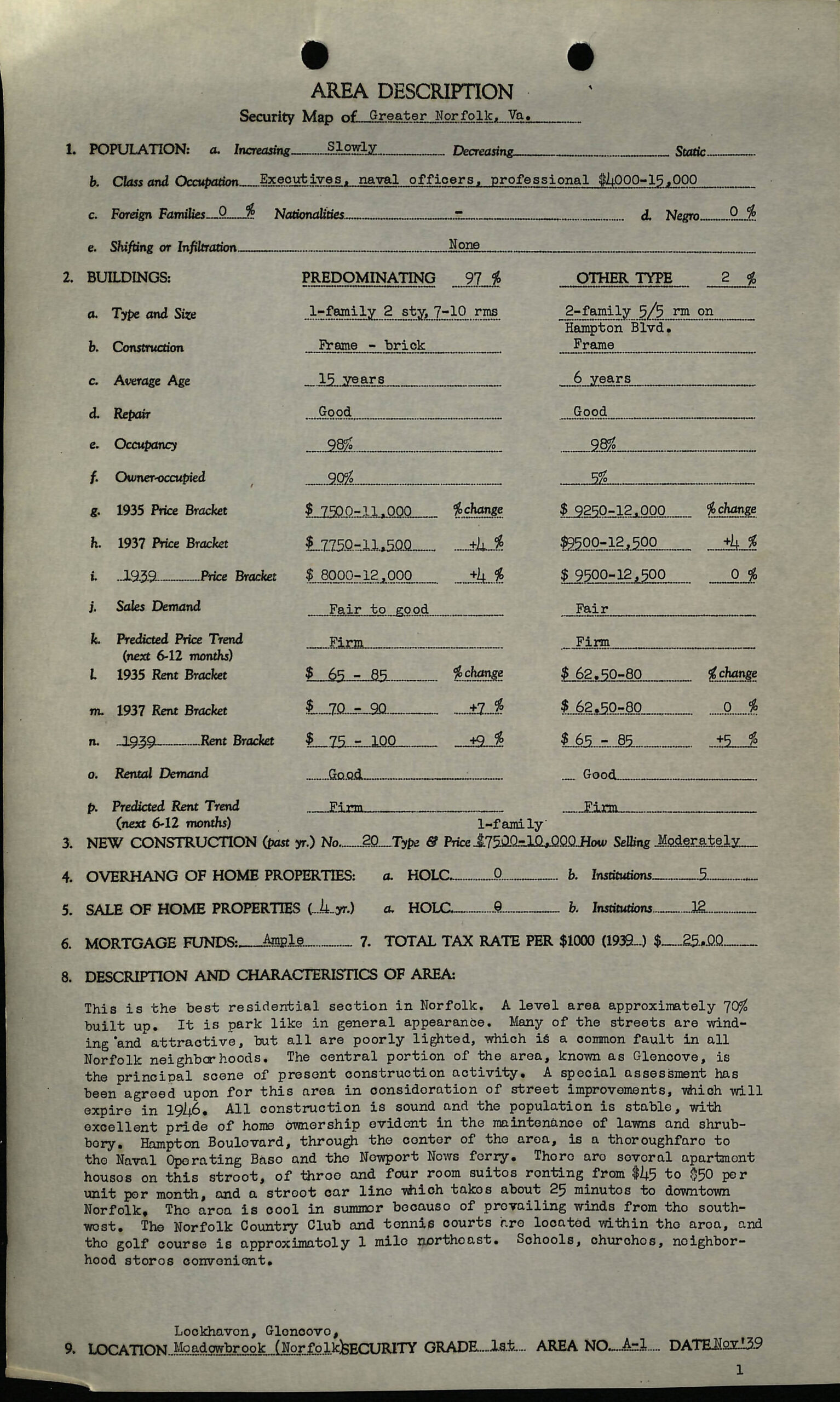
The forces of urban renewal would dramatically reshape the urban and racial geography of Norfolk, Virginia. As in other cities across the state and country, Norfolk’s racial geography in the 1930s already exhibited the hallmarks of significant public and private investment in white neighborhoods and disinvestment in Black ones. Take, for instance, the written descriptions from the 1940 HOLC “redlining” map of two Norfolk neighborhoods, one white and one Black, just miles apart from each other. The all-white Lockhaven neighborhood was described as “the best residential section in Norfolk” that was “park like (sic) in general appearance” (fig. 4). The description continues:
Many of the streets are winding and attractive …. The central portion of the area, known as Glencove, is the principal scene of present construction activity. A special assessment has been agreed upon for this area in consideration of street improvements, which will expire in 1946. All construction is sound and the population is stable, with excellent pride of home ownership evident in the maintenance of lawns and shrubbory (sic) …. The area is cool in summer because of prevailing winds from the southwest. The Norfolk Country Club and tennis courts are located within the area, and the golf course is approximately 1 mile northeast. Schools, churches, neighborhood stores convenient.43
Less than five miles south, a segregated and redlined neighborhood east of downtown that would later come to be called St. Paul’s Quadrant exhibited the blighted housing conditions that would soon be characterized as slums, thus justifying their removal (fig. 5):
A level area practically 100% built up with small houses, many of which are in rows, others are closely built on narrow lots of 25 feet or less (in some cases 3 houses have been built on a 50-foot lot). Many of the frame shacks and other nondescript dwellings are in a dilapidated condition. Most of the large one-family houses have been converted at minimum expense for two or more families. Most of the inhabitants are poor class negroes and many are on relief …. Very few homes have central heating plants and practically none have bathrooms …. There is a Hebrew cemetery in the northeast corner of the area and there is a gas production plant at Monticello Ave. and Starr St. The area is adjacent to the downtown business section of Norfolk and there is industry to the south and east …. A number of streets hard surfaced, but many dirt streets, unsightly with ruts and mudholes, particularly to the east and northeast parts of the area. Poorly lighted.44
In 1936, the Works Progress Administration (WPA) surveyed 2,000 housing units in several of Norfolk’s Black neighborhoods, concluding that more than 75 percent lacked flush toilets and baths, and more than 200 were totally unfit for human habitation.45 In 1940, Nathan Straus, then head of the FHA, toured this and other blighted areas of the city, noting that this was, “without a doubt the worst slum he had seen anywhere in the United States.” He told city leaders that Norfolk would be “first on the list” for redevelopment funds.46
In 1938 the Virginia General Assembly passed legislation allowing cities and municipalities to create local housing authorities, and in 1940 Norfolk City Council voted to create the Norfolk Housing Authority as the city’s primary vehicle to marshal federal housing funds (BWB; URN). By the end of WWII the term “redevelopment” was added to its title, and slum clearance and urban renewal became central to the mission of the NRHA. A 1949 master plan for urban renewal in Norfolk described extensive blight and concluded that “large scale redevelopment is the only chance the city ever has had to accomplish a drastic modernization of its heart” (BWB, 13).
What followed was a classic self-fulfilling prophecy within urban renewal. Through both formal statements and informal telegraphing, city leaders would single out specific neighborhoods as blighted and in need of redevelopment. In many specific cases, these neighborhoods were vibrant, if run-down communities. The depiction of these areas as blighted by city leaders, however, disincentivized the city from extending or continuing to provide services to areas that may soon be redeveloped and landlords and homeowners from continuing to invest in their properties, concerned that the city would ultimately bulldoze their investments. As I show below, public and private disinvestment came as a result of telegraphing slum clearance and, in many cases, exacerbated or even created the very slum conditions that would ultimately justify their removal (BWB).
An analysis of urban renewal in Norfolk cannot be separated from the racist and sometimes violent backlash to the Supreme Court’s landmark decision in Brown v. Board of Education (1954) happening across Virginia at the same time.47 Known as Massive Resistance, local and state political leaders across Virginia adopted a set of strategies to resist public school integration. One strategy was simply to close public schools rather than integrate them.48 Schools in Norfolk, for instance, closed for five months in 1958, while Prince Edward County public schools closed for five full years, only reopening after the Supreme Court deemed these closures to be unconstitutional.49 Another strategy was the creation of “segregation academies,”50 publicly-funded segregated white private schools that wouldn’t be forced to integrate until 1976 when the U.S. Supreme Court found them to be contrary to federal law.51 Nearly two dozen segregation academies opened in Virginia.
Beyond school closures and segregation academies, city leaders in Norfolk also reasoned that if they could maintain residential racial segregation in neighborhoods, they could maintain de facto segregated public schools, even in the face of Brown (BWB). Slum clearance and urban renewal became the primary vehicle to achieve this end. Between 1951 and the formal end of urban renewal in 1973, every single racially integrated neighborhood in Norfolk was targeted for slum clearance. Populations were displaced, neighborhoods were bulldozed, and racial segregation was not only maintained but deepened (URN).
Project One
In 1951, the city broke ground on Project One (fig. 6), the first urban renewal project in the United States. This project was focused in the area described above that is today known as St. Paul’s Quadrant. At the time, the census tracts that made up the area were over 95 percent African American. After decades of neglect and disinvestment, the area represented some of the most squalid, blighted neighborhoods in the country (BWB). Project One would ultimately bulldoze and redevelop a 250-acre swath of land immediately adjacent to downtown Norfolk. And while Project One did result in a net increase in housing for African American families, this housing was concentrated in segregated low-rise public housing developments named Young Terrace, Calvert Square, and Tidewater Gardens. A new school—Tidewater Park Elementary—was built among the public housing developments and was specifically designed to relieve pressure to integrate nearby public schools (BWB). More than one-third of the land cleared for Project One was transformed into highways and industrial zones, physical barriers isolating the new public housing projects and reinforcing the lines of racial segregation. This was the first and only urban renewal project in Norfolk that would result in the construction of housing for the population that it displaced.
Project Two
Following the completion of Project One, the city launched Project Two, which would ultimately result in the demolition of the city’s last integrated neighborhoods, Broad Creek Village, Atlantic City, Lamberts Point, and East Main St. (fig. 7).
Broad Creek Village was a segregated white wartime housing project that was cheaply constructed in the early 1940s for military workers and their families. After WWII and following the desegregation of the U.S. military, the area quickly became racially integrated. In 1955, the city began discussing slum clearance in Broad Creek Village. As happened in so many other areas, reference to slum clearance itself meant that landlords stopped investing in their properties (BWB). The NRHA took control of Broad Creek Village later that year, and in 1958, it was rezoned as industrial and bulldozed specifically to prevent the development of African American housing in the area. The city did allow Black leaders to develop a 16-acre parcel known as Broad Creek Shores, but only after “the City’s chief concern, that (white) Ingleside Elementary School remain widely separated from [B]lack housing, was met” (BWB).
Atlantic City was a small, working-class neighborhood of approximately 1,000 households located southwest of downtown Norfolk. In the early 1950s, many Black families displaced by Project One were able to find rental units owned by absentee landlords in the area. By the mid 1950s, Atlantic City had become one of the only predominantly white neighborhoods where the African American population was greater than ten percent, and Atlantic City would also be the only majority white neighborhood targeted for urban renewal. According to White:
At a time when the severe housing crisis in the community had precipitated subdividing many older homes into multi-unit apartments, almost a quarter of the Atlantic City homes were till single-family, freestanding houses; another fourth were duplexes …; and close to 20 percent of the homes were less than thirty years old. In addition, more than 70 percent of the units had adequate plumbing …. More than half the units had central heating …. Undoubtedly, a number of structures had deteriorated beyond rehabilitation … but many of the deficiencies … were not only in keeping with exiting city codes, but they were also common practices during the local wartime and postwar housing crises. (BWB, 82)
The city’s health department had even run a concentrated housing code enforcement and nearly every dwelling had been brought up to code. Even so, city leaders began discussing Atlantic City’s redevelopment, causing homeowners and landlords alike to abandon property upkeep. Ultimately 1,000 homes were demolished to make way for the construction of Norfolk General Hospital and an expansion of surrounding highways and tunnels (URN). This redevelopment did not include any new housing.
Lambert’s Point was another of Norfolk’s few racially integrated neighborhoods. Census data shows that in 1940, this area was approximately thirty percent African American. Beginning in the early 1950s, Old Dominion University overtook nearly forty square blocks of the historically African American portion of Lambert’s Point. This redevelopment did not include any new housing, and today the primarily African American residential section of Lambert’s Point has been reduced to the most environmentally marginalized blocks immediately adjacent to the Norfolk Southern railyard and coal terminal. The final Project Two neighborhood was East Main Street, a majority Black section of downtown Norfolk containing some of the city’s worst slums. The redevelopment of this section of downtown resulted in the demolition of approximately 400 commercial buildings and 500 residences. No new housing was constructed. Today, East Main Street bisects the Waterside district, an area that includes the Hilton, Marriott, and Sheraton hotels, and numerous high-end restaurants and commercial buildings (URN).
Project Two “wipe[d] out all of the city’s … neighborhoods where indistinct color lines had failed to produce two distinct neighborhood school communities, one black and the other white” (BWB, 101). In the end, nearly 800 acres of land were cleared, no new housing was constructed, and an estimated 20,000 people—ten percent of the city’s population—were displaced.
East Ghent Renewal Project
The last urban renewal project in Norfolk was the redevelopment of East Ghent (fig. 8). Situated just north of downtown Norfolk, East and West Ghent were originally developed in the 1890s as upscale, segregated, white planned communities.52 Temporary war housing was built in sections of East Ghent during WWII, which deteriorated rapidly in the years following the war. As white families abandoned East Ghent for the newly developing post-war suburbs outside of downtown, African American families, displaced from other parts of the city as a result of Project Two, began relocating into East Ghent.53 An analysis of census data shows that the population shift was so pronounced that the racial makeup of the neighborhood flipped from ninety-eight percent white to ninety percent Black in the twenty years between 1950 and 1970. In the late 1960s, city leaders declared East Ghent as blighted, and in 1969, the federal government approved the East Ghent Renewal Project. Soon thereafter, the NRHA began notifying Black residents that their properties would be acquired through eminent domain. In the end, nearly ninety acres were razed. Unlike Project Two, this urban renewal project did result in the construction of new housing, with city officials promising displaced families that they could return to the newly developed affordable housing that would be built in its place (URN). Ultimately, however, the city opted to expand its tax base by building upper middle-class homes and townhomes.54 By 1980, census data shows that the population of East Ghent was less than ten percent African American.
The End of Urban Renewal
If the 1972 demolition of Pruitt-Igoe is widely understood as symbolic of the failure of public housing policy in this era, the Housing and Community Development Act of 1974 formally ended the period of urban renewal in the United States. One of the HCDA’s most notable provisions was the creation of the Section 8 Housing Program, which represented a major shift away from public housing and toward an emphasis on flexibility and choice for low-income households in the private rental market. A generation later, the Quality Housing and Work Responsibility Act of 1998 rebranded Section 8 vouchers as “Housing Choice Vouchers,” further entrenching the neoliberal buzzwords of flexibility and choice in low-income housing policy.
But this language is an ideological trick that hides the fact that intentionally discriminatory social forces produced the urban landscapes of racialized inequality that we inhabit today. The new discursive emphasis on flexibility and choice effectively shifts the responsibility of segregation and poverty onto impoverished people of color who—now unincumbered by discriminatory laws, policies, regulations, or individuals—have the “freedom” to “choose” to live wherever they want.
But the symbolic playing field (and literal urban landscape) is anything but level. The legacy of a century of disinvestment, slum clearance, and housing discrimination in Black communities, in contrast to the subsidization of white wealth creation through suburban home ownership, is a yawning racial wealth gap. In 2022, median Black family net worth was just fifteen percent of median white family net worth in the United States.55 In Hampton Roads specifically (the broader metro area that encompasses Norfolk), my analysis of census data shows a strong and statistically significant negative correlation between Blackness and home value. Controlling for median household income, median home values drop $700 for every percentage increase in a census tract’s African American population.56 Nationally, a 2020 study found that over 80 percent of metro areas with more than 200,000 residents in the United States were more racially segregated in 2019 than they were in 1990.57 Taken together with the continuance of restrictive zoning in suburbs from Baltimore to Berkeley and the ongoing discriminatory practices of realtors,58 banks,59 home appraisers,60 and even progressive NIMBYs,61 the landscape no longer needs racially restrictive covenants, slum clearance, or any other overtly discriminatory policy to achieve the very same result.
History repeats itself in Tidewater Gardens
What does this history mean for us today, half a century after the formal end of urban renewal? For one, the urban landscapes produced by urban renewal are the very landscapes we inhabit today: the public housing projects of St. Paul’s Quadrant, the Broad Creek Industrial Park, the still overwhelmingly white East Ghent. But even as these landscapes persist, the intentionality of the racism embedded within the urban renewal policies that produced them disappears into them, and a neutral, seemingly objective landscape becomes the physical stage upon which a neoliberal ideology of housing choice freedom plays out.
This article opened with the recent demolition of Tidewater Gardens, a 618-unit public housing development just east of downtown Norfolk. In early 2021, in the midst of a federal Fair Housing lawsuit brought by public housing residents against the city and the NRHA and amidst a cascade of bad press locally and nationally, Norfolk City Manager Chip Filer and NRHA Executive Director Ronald Jackson penned an op-ed in the Virginian-Pilot arguing that despite the NRHA’s long history of displacing Black families, Tidewater Gardens residents would this time have true choices: they could choose to return to the newly developed mixed-income housing, they could choose to use an HCV to rent in higher opportunity neighborhoods, or they could simply choose home ownership.62
But framing these as choices effectively places the blame on public housing residents for being displaced, for not renting in a better neighborhood, for not simply purchasing a home. My own analysis of HCV usage in Norfolk shows the limits of housing choice. Working together with a team of journalists63 and using the NRHA’s own data, I mapped all voucher usage citywide during a three-month period in late 2020. My analysis showed (and as I wrote in the Virginian-Pilot in response to Filer and Jackson64) that across Norfolk, two-thirds of HCVs were used in majority Black neighborhoods, and more than sixty percent were used in census tracts with poverty rates higher than the city-wide average. Almost three-quarters were used in the forty percent most socially vulnerable census tracts, while just six percent were used in the least vulnerable quintile. In short, the geography of HCVs showed that they re-concentrate non-white and high-poverty populations in other non-white, high-poverty neighborhoods.
Even so, when we take a step outside and have a look around, we see what we are told are just individuals making individual choices about where to live, work, and send their kids to school. It’s not just that the landscape erases the forces of its own production, but also that the racial inequality naturalized into the landscape then becomes a powerful ideological weapon in furtherance of the very structural forces that perpetuate ongoing spatialized and racialized urban inequality.
Postscript
In 2018, Norfolk City Council voted to approve the demolition of all 1,674 public housing units that comprise St. Paul’s Quadrant—the very same three projects, Young Terrace, Calvert Square, and Tidewater Gardens, that were constructed as a part of Project One nearly three quarters of a century ago. In 2020, Norfolk received a $30 million HUD Choice Neighborhoods Initiative (CNI) grant, awarded specifically for the redevelopment of Tidewater Gardens. Later that year, removals began. After a delay resulting from a lawsuit brought by public housing residents, demolition began in early 2021. Initial construction focused on underlying infrastructure, especially flood prevention, and later construction of new housing units. The first new housing units, reserved for low-income senior citizens, opened in 2023. In April of 2024, the NRHA issued a formal Request for Qualifications for Developer Partners that specifically named the other two urban renewal-era public housing projects—Young Terrace and Calvert Square—as “Future Transformation” properties.65 As of writing this in late 2024, the overwhelming majority of residents displaced from Tidewater Gardens over four years ago have yet to return.
Notes